





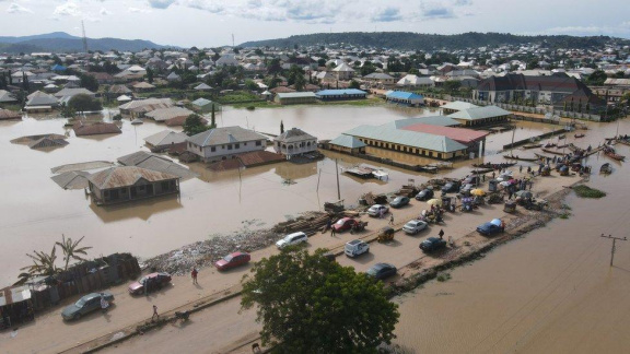
More than 8,000 communities and 4,500 schools across 15 states have been identified as being at risk of flooding between September 19 and 25, 2026, following a high riverine flood-risk advisory issued by the Nigeria Hydrological Services Agency (NiHSA).
The advisory, designated NFA-2026-262, was issued by NiHSA Director-General and Chief Executive Officer, Arch. Umar Mohammed, amid forecasts of rising river levels and increased risk of flooding in vulnerable communities. The agency said nine river stations require close monitoring during the period.
The 15 states listed in the advisory are Imo, Cross River, Ebonyi, Benue, Anambra, Akwa Ibom, Lagos, Rivers, Edo, Kogi, Taraba, Delta, Bayelsa, Enugu and Abia. NiHSA warned that rising river stages could result in flooding, particularly in communities located on floodplains and near major waterways.
The potential impact extends beyond residential areas, with schools, healthcare facilities, markets, religious buildings and farmlands among the assets identified as exposed to flooding. NiHSA consequently urged state governments and communities in vulnerable locations to take precautionary measures ahead of possible inundation.
In Imo State, the agency identified Aboh-Mbaise, Ahiazu-Mbaise, Ehime Mbano, Ezinihitte, Ideato North, Ihitte/Uboma and Ikeduru Local Government Areas as vulnerable. It estimated that 958 communities, 1,022 schools, 553 healthcare facilities, 161 markets and 198 religious buildings are exposed in the state.
Cross River State has also been identified as a significant area of concern. The affected local government areas include Abi, Akamkpa, Akpabuyo, Biase, Calabar, Calabar South, Ikom and Obubra. NiHSA listed 2,471 communities, 703 schools, 344 healthcare facilities, 145 markets and 453 religious buildings as exposed, alongside 854 hectares of farmland.
In Ebonyi State, Abakaliki, Afikpo, Afikpo South, Ebonyi, Ezza North and Ezza South are among the vulnerable areas. The agency identified 2,574 communities and 1,064 schools as exposed, in addition to 422 healthcare facilities, 480 markets, 629 religious buildings and 1,882 hectares of farmland.
The advisory also identified six local government areas in Benue State — Buruku, Gboko, Guma, Katsina-Ala, Logo and Ukum — with 303 communities, 100 schools, 48 healthcare facilities, 32 markets and 151 religious buildings exposed to the risk. In Anambra, seven local government areas were listed, with 1,314 communities and 1,308 schools among the facilities identified as vulnerable.
In Akwa Ibom, the affected areas include Abak, Eket, Etinan, Ibeno, Ibesikpo Asutan, Ibiono Ibom, Ika and Ikono. NiHSA identified 249 communities, 323 schools, 211 healthcare facilities, 74 markets and 289 religious buildings as exposed. The agency similarly listed areas across Edo, Bayelsa, Enugu, Kogi, Delta, Abia, Taraba, Rivers and Lagos for heightened vigilance.
Authorities have urged residents in flood-prone communities, especially those living on floodplains and close to rivers, to remain alert and move to higher ground where necessary. In Lagos, the state government has already directed residents in low-lying and flood-prone areas to relocate temporarily to safer locations, while intensifying monitoring of vulnerable communities and waterways.
NiHSA’s warning underscores the importance of early action as the forecast period continues. Residents are advised to follow official flood alerts, avoid driving or walking through fast-moving floodwater, protect essential belongings and make arrangements for temporary relocation where authorities identify an imminent threat.
- Dangote Refinery’s N2.15 Trillion IPO Closes Today as Investors Make Final Push
 LAGOS, Nigeria — The highly anticipated initial public offering (IPO)…
Read More “Dangote Refinery’s N2.15 Trillion IPO Closes Today as Investors Make Final Push” »
- NCAA to Probe Airline After Passenger Reportedly Bleeds Amid Extreme Heat on Abuja–Calabar Flight
 The Nigeria Civil Aviation Authority (NCAA) is set to investigate…